Aerial view of the Maldives by pakhnyushchyy via FREEPIK
Issue
There was a need to identify climate risk hotspots and assess the exposure of climate-sensitive sectors in the Maldives. However, the acquisition of downscaled climate projection data, essential for conducting the climate exposure analysis, posed significant challenges.
Solution
The United Nations Economic and Social Commission for Asia and the Pacific (ESCAP) collaborated with AP-PLAT to obtain downscaled climate projection data for the Maldives. ESCAP then integrated the climate data developed by AP-PLAT with sector-specific information to pinpoint risk hotspots.
Overview
The Maldives is one of the Small Island Developing States (SIDS) and ranks among the most vulnerable countries to the potential impacts of climate change. The geographical isolation, small landmass, and limited natural resources of these low-lying islands make the Maldives particularly vulnerable to existing natural hazards and future climate change impacts.
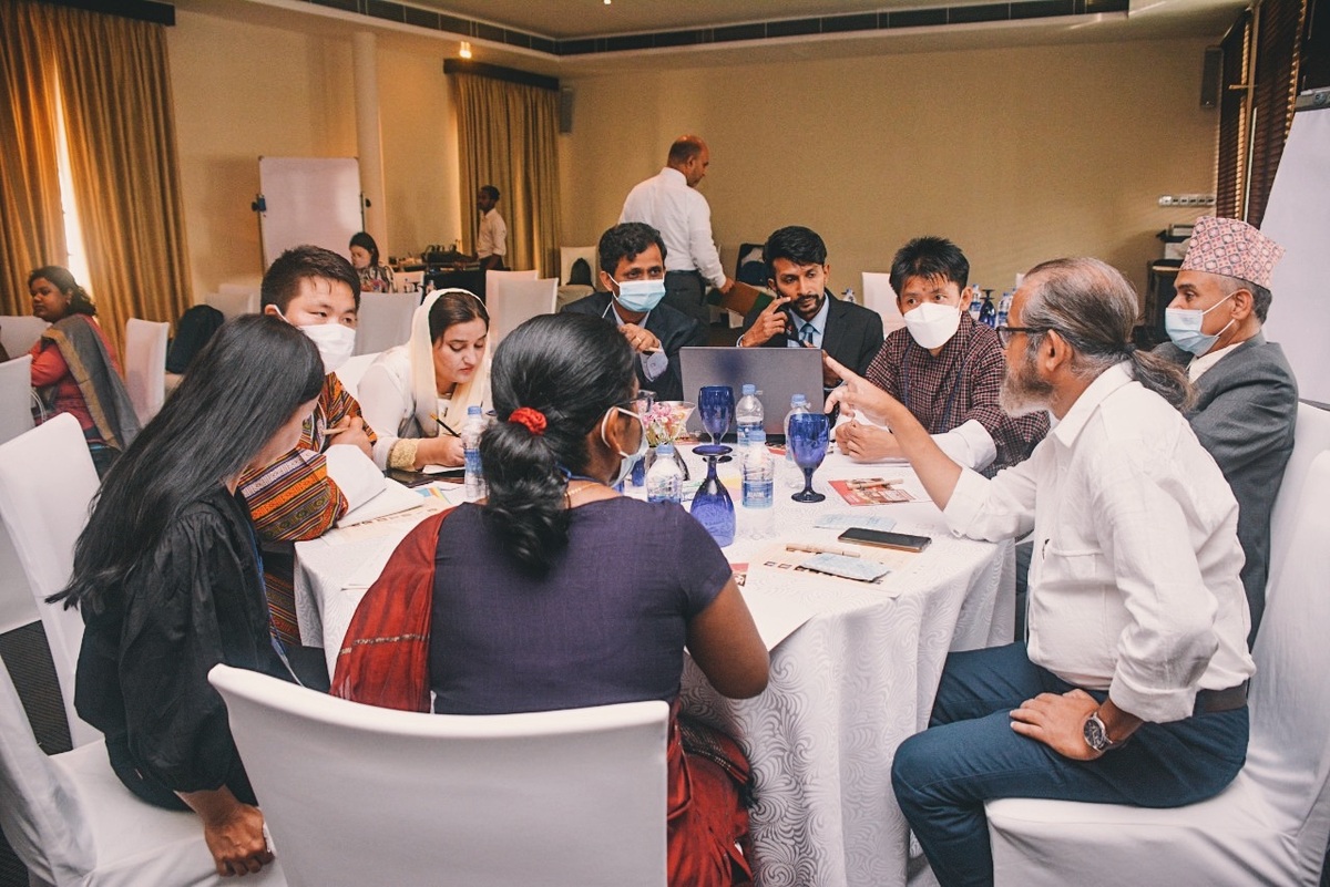
As part of the joint project on “Strengthening National and Subnational Capacity for Sustainable Disaster Risk Reduction, Climate Change Adaptation and Mitigation in Maldives,” funded by the Sustainable Development Goals Fund (SDG Fund), ESCAP is identifying the risk hotspots and assessing the exposure of climate-sensitive sectors in the Maldives concerning climate related hazards. In this process, the downscaled climate projection data developed by AP-PLAT is overlaid with sectoral information, including demographic data, land use, and critical infrastructure, to identify the risk hotspots. This approach has immensely enhanced the understanding of the climate risks, vulnerability and most affected sectors in Maldives at the sub-national level.
The visualization of climate exposure is available on the ESCAP Risk and Resilience Portal - Maldives Decision Support Tool.
Figures: Climate Scenario Exposures in the Maldives (2041-2060)
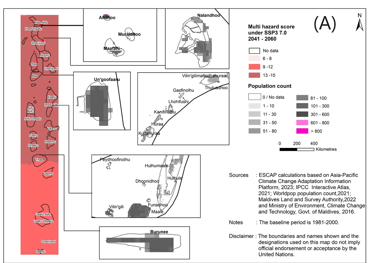
(A) Female Population Exposure to Multi-Hazard under SSP3 7.0: This section of the figure depicts the female population in the Maldives exposed to multi-hazard conditions as projected for the climate scenario SSP3 7.0 for the years 2041-2060. Multi-hazards refer to a combination of various climate-related risks, which may impact this specific demographic group.

(B) Total Population Exposure to Annual Precipitation under SSP3 7.0: In this part of the figure, we illustrate the total population in the Maldives exposed to annual precipitation levels as projected under the SSP3 7.0 climate scenario for the years 2041-2060. This data provides insight into the vulnerability of the entire population to changes in annual precipitation patterns.
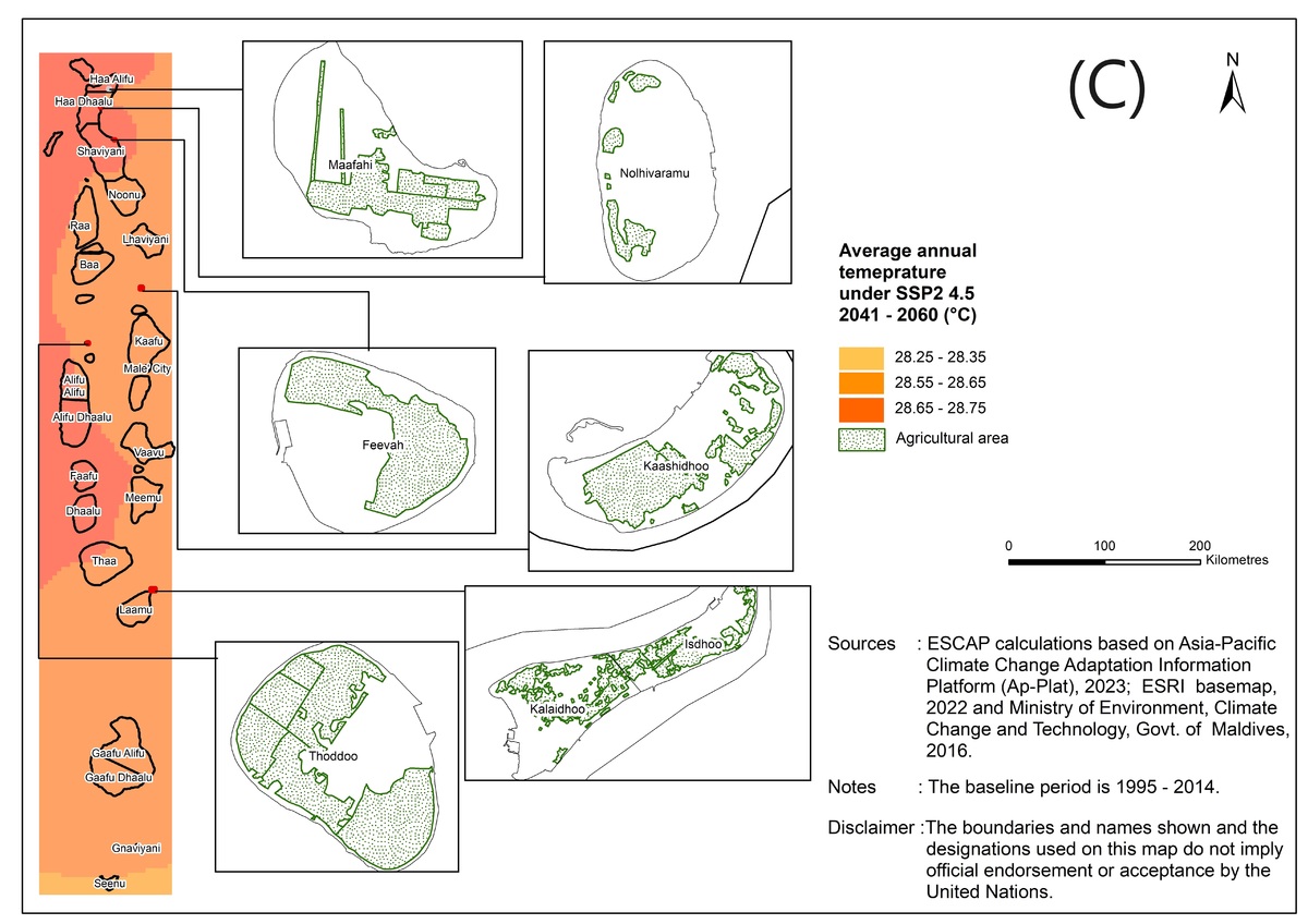
(C) Agricultural Area Exposure to Average Annual Temperature under SSP2 4.5: This segment of the figure focuses on the agricultural areas in the Maldives exposed to average annual temperature changes under the SSP2 4.5 climate scenario for the period 2041-2060. It offers information on how these climate conditions may impact agricultural practices and food security.
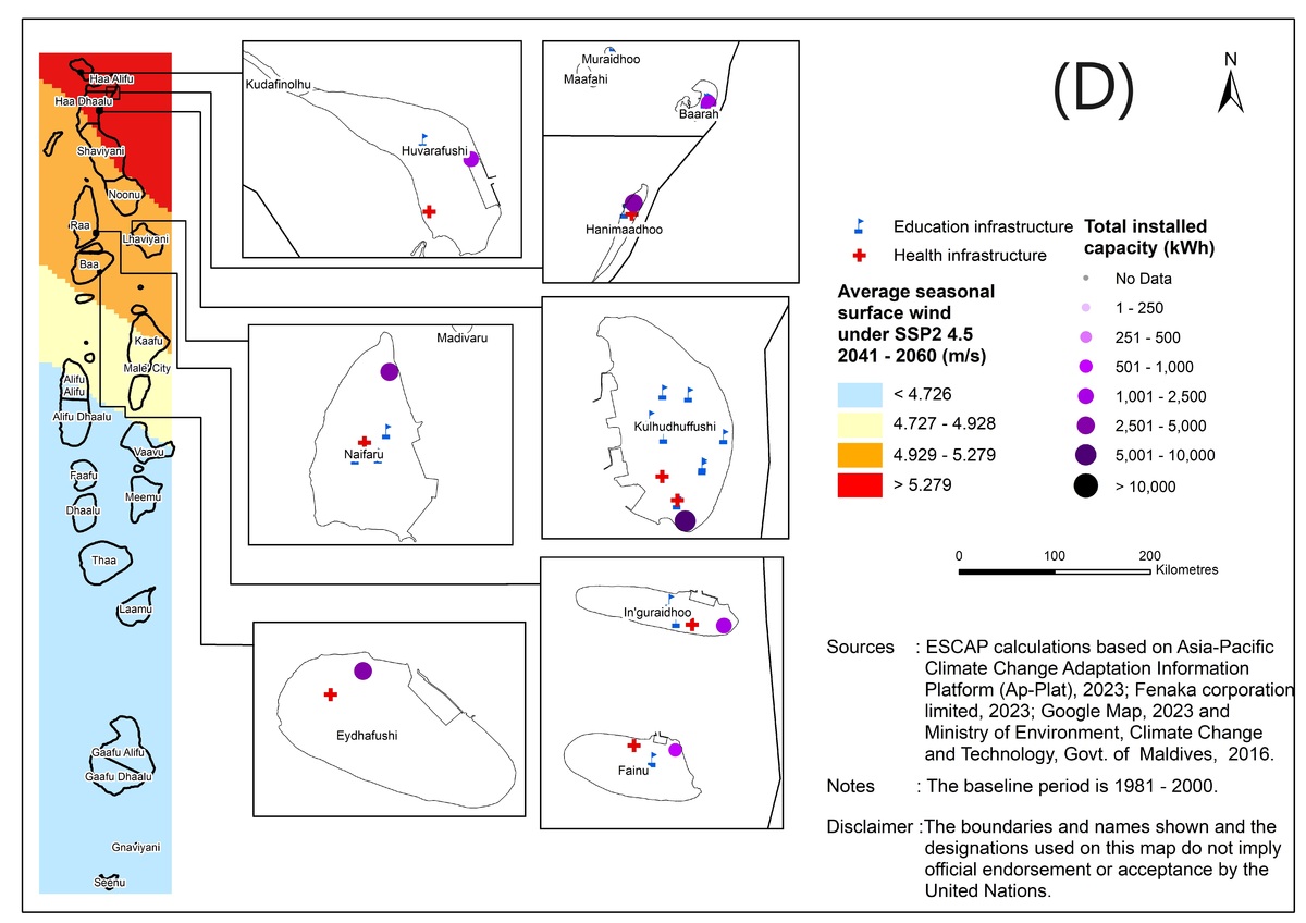
(D) Critical Infrastructure Exposure to Seasonal Average Surface Wind under SSP2 4.5: In this part of the figure, we present data on the exposure of critical infrastructure in the Maldives to seasonal average surface wind conditions projected under the SSP2 4.5 climate scenario for the years 2041-2060. This information is crucial for assessing the resilience of vital infrastructure in the face of changing wind patterns.
Key findings
The following are some of the key findings:
- As climate hazards are expected to intensify, so too will the direct impacts on exposed populations. ESCAP's analysis reveals that currently, 13 percent of the female population in the Maldives is exposed to multi-hazard risks. However, under different climate change scenarios, this percentage is projected to increase to as much as 99 percent by 2060 (Figure A). The Maldivian islands frequently experience intense precipitation, leading to waterlogging and flood-like situations. By 2060, approximately 50 percent of the total population of the Maldives is likely to be exposed to heightened risks of precipitation and related flooding under the SSP2 4.5 scenario, and around 55 percent under the worst-case scenario, SSP3 7.0, compared to 27 percent under the baseline scenario. Notably, while the highest number of exposed individuals resides in the capital city, those living in the remote islands are the most vulnerable (Figure B).
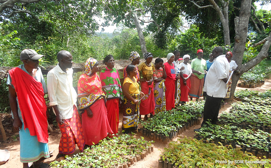
- Intense precipitation is also poised to impact agricultural activities in the Maldives. Up to 26 percent of the country's agricultural lands may face heightened risks of flooding under SSP3 7.0 by 2060. Thoddoo Island, the largest producer of fruits, vegetables, and salad leaves in the Maldives, is exposed to intensified precipitation under the worst-case scenario by 2060. This projected impact is significant, particularly given the current agricultural policy's encouragement to increase local agricultural production for domestic consumption. Additionally, 86 percent of the total agricultural land is exposed to up to a 1.6 °C increase in the annual average temperature and the potential for water scarcity. This includes atolls with comparably larger areas under agriculture, such as Laamu, Shaviyani, and Kaafu atolls (Figure C).
- Critical infrastructures, including energy, education, and healthcare facilities, are at risk from climate change and its impacts. Approximately 47 percent of the total installed energy capacity and 28 percent of other critical infrastructure in the country are exposed to the highest increases in precipitation and flood-like situations by the end of 2060 under both the SSP2 4.5 and SSP3 7.0 climate change scenarios. The impacts of intensified surface wind and storm-like scenarios are projected to be more significant in the near-term period (2021 – 2040). Around 28 percent of the total installed energy capacity and 41 percent of other critical infrastructure in the country are likely to be exposed to intense surface wind, with the majority of them located in the northern islands.
Project Information
Project Name: Strengthening National and Subnational Capacity for Sustainable Disaster Risk Reduction, Climate Change Adaptation, and Mitigation in the Maldives
Funding: The project is funded by the United Nations Sustainable Development Goals Fund (UN SDG Fund), with a total budget of USD 957,390.
Implementation Entities: The project is jointly implemented by ESCAP and UNDP Maldives in partnership with the Maldives National Disaster Management Authority and the Ministry of Environment, Climate Change and Technology (Maldives Met Service).
Duration: January 1, 2022 - March 31, 2024 (27 months)
ACKNOWLEDGEMENTS
We express our gratitude to the United Nations Economic and Social Commission for Asia and the Pacific (ESCAP) for their generous contribution of this case study to the database.
Related Information
- Project overview: Strengthening National and Subnational Capacity for Sustainable Disaster Risk Reduction, Climate Change Adaptation and Mitigation in Maldives
- United Nations Economic and Social Commission for Asia and the Pacific (ESCAP)
- United Nations Development Programme (UNDP)
- Sustainable Development Goals Fund (SDG Fund)
- ESCAP Risk and Resilience Portal - Maldives Decision Support Tool - Visualization
- Related case study: Climate Risk Projections Using AP-PLAT Data in the Maldives
KEYWORDS
- # Case Study
- # Agriculture
- # Coastal Areas
- # Energy
- # Human Health
- # Infrastructure
- # Life of Citizenry and Urban Life
- # Natural Disasters
- # Tourism
- # Climate Projection
- # Disaster Prevention/Disaster Mitigation
- # Impact Assessment/Risk Assessment
- # International Cooperation
- # Asia
- # Maldives
- # 2023